
Thank you for supporting this site ❤️
Make a donation
Make a donation
Vaduvanchal topographic map
Click on the map to display elevation.
Thank you for supporting this site ❤️
Make a donation
Make a donation
About this map
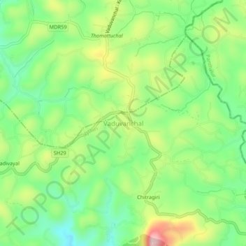
Name: Vaduvanchal topographic map, elevation, terrain.
Location: Vaduvanchal, Vythiri, Wayanad, Kerala, 673581, India (11.53483 76.20270 11.57483 76.24270)
Average elevation: 858 m
Minimum elevation: 746 m
Maximum elevation: 1,041 m
Thank you for supporting this site ❤️
Make a donation
Make a donation
Other topographic maps
Click on a map to view its topography, its elevation and its terrain.