
Thank you for supporting this site ❤️
Make a donation
Make a donation
Porto San Giorgio topographic map
Click on the map to display elevation.
Thank you for supporting this site ❤️
Make a donation
Make a donation
About this map
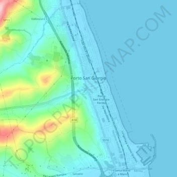
Name: Porto San Giorgio topographic map, elevation, terrain.
Location: Porto San Giorgio, Fermo, Marche, 63822, Italy (43.16158 13.76045 43.19904 13.81360)
Average elevation: 33 m
Minimum elevation: -2 m
Maximum elevation: 212 m
Thank you for supporting this site ❤️
Make a donation
Make a donation
Other topographic maps
Click on a map to view its topography, its elevation and its terrain.