
Thank you for supporting this site ❤️
Make a donation
Make a donation
Gegharkunik Province topographic map
Click on the map to display elevation.
Thank you for supporting this site ❤️
Make a donation
Make a donation
About this map
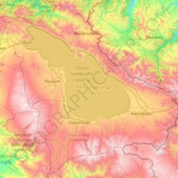
Name: Gegharkunik Province topographic map, elevation, terrain.
Location: Gegharkunik Province, Armenia (39.87198 44.77966 40.74022 45.97991)
Average elevation: 2,141 m
Minimum elevation: 900 m
Maximum elevation: 3,536 m
Thank you for supporting this site ❤️
Make a donation
Make a donation
Other topographic maps
Click on a map to view its topography, its elevation and its terrain.
Gyumri
Armenia > Shirak Province > Gyumri
Gyumri is 126 kilometres (78 miles) north of the capital Yerevan at the central part of the Shirak plateau. It has an approximate height of 1,550 metres (5,090 feet) above sea level, the high altitude line being 1,500 metres (4,900 feet). The Akhurian River passes through the western suburbs. The Shirak…
Average elevation: 1,535 m