
Make a donation
Albano Laziale topographic map
Click on the map to display elevation.
Make a donation
Albano Laziale
The highest peak of the town of Albano is the Colle dei Cappuccini, located at 615 m above sea level. From the hill, which houses a pine forest adjacent to the Capuchin Monastery, there is a remarkable overview of Lake Albano, Agro Romano and Monte Cavo. The historic center of Albano has a maximum gradient of 11%, or 47 metres, 435, taking into consideration the distance between the Cathedral of San Pancrazio (384 m asl) and the St. Paul's Church (431 m asl). Other altitudes through the center of town are Villa Altieri, at kilometre 25 of the State Road 7 Via Appia (363 m asl) and the Church of Stella (391 m asl). The hill town of Castel Savelli is 280 m above sea level, while the underlying fraction of Pavona is built at 110 m above sea level. The village of Cecchina at the railway station is located at 212 m above sea level.
Make a donation
About this map
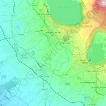
Name: Albano Laziale topographic map, elevation, terrain.
Location: Albano Laziale, Roma Capitale, Lazio, 00041, Italy (41.67321 12.59029 41.75334 12.69444)
Average elevation: 302 m
Minimum elevation: 106 m
Maximum elevation: 951 m
Make a donation
Other topographic maps
Click on a map to view its topography, its elevation and its terrain.
Rome
Italy > Lazio > Roma Capitale
Although the city centre is about 24 km (15 mi) inland from the Tyrrhenian Sea, the city territory extends to the shore, where the south-western district of Ostia is located. The altitude of the central part of Rome ranges from 13 m (43 ft) above sea level (at the base of the Pantheon) to 139 m (456 ft) above…
Average elevation: 78 m
Make a donation
Make a donation
Make a donation
Make a donation