
Make a donation
Ciudad Guayana topographic map
Click on the map to display elevation.
Make a donation
About this map
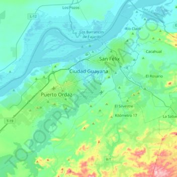
Name: Ciudad Guayana topographic map, elevation, terrain.
Average elevation: 85 m
Minimum elevation: 1 m
Maximum elevation: 508 m
Make a donation
Other topographic maps
Click on a map to view its topography, its elevation and its terrain.
Guiana Highlands
Venezuela > Bolivar State > Municipio Angostura
The Guiana Shield (French: Plateau des Guyanes, Bouclier guyanais; Dutch: Hoogland van Guyana, Guianaschild; Portuguese: Planalto das Guianas, Escudo das Guianas; Spanish: Escudo guayanés) is one of the three cratons of the South American Plate. It is a 1.7 billion-year-old Precambrian geological formation in…
Average elevation: 524 m
Cerro Sarisariñama
Venezuela > Bolivar State > Municipio Sucre
Cerro Sarisariñama is a tepui, a flat-topped mountain in Jaua-Sarisariñama National Park at the far south-west of Bolívar State, Venezuela, near the border with Brazil. Its altitude range is between 300 m (980 ft) and 2,350 m (7,710 ft). The name of the mountain originates from the tale of the local…
Average elevation: 1,297 m
Make a donation
Make a donation
Make a donation