
Thank you for supporting this site ❤️
Make a donation
Make a donation
San José topographic map
Click on the map to display elevation.
Thank you for supporting this site ❤️
Make a donation
Make a donation
About this map
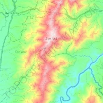
Name: San José topographic map, elevation, terrain.
Location: San José, Bajo Occidente, Caldas, Colombia (5.00425 -75.85932 5.12609 -75.76039)
Average elevation: 1,184 m
Minimum elevation: 820 m
Maximum elevation: 1,809 m
Thank you for supporting this site ❤️
Make a donation
Make a donation
Other topographic maps
Click on a map to view its topography, its elevation and its terrain.