
Thank you for supporting this site ❤️
Make a donation
Make a donation
Dawson Island topographic map
Click on the map to display elevation.
Thank you for supporting this site ❤️
Make a donation
Make a donation
About this map
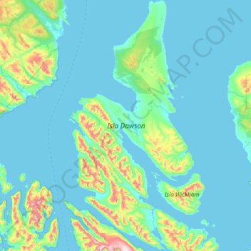
Name: Dawson Island topographic map, elevation, terrain.
Average elevation: 106 m
Minimum elevation: -1 m
Maximum elevation: 1,084 m
Thank you for supporting this site ❤️
Make a donation
Make a donation
Other topographic maps
Click on a map to view its topography, its elevation and its terrain.
Cabo Conventry
Chile > Magallanes and Chilean Antarctica Region > Provincia de Magallanes > Punta Arenas
Average elevation: 19 m