
Thank you for supporting this site ❤️
Make a donation
Make a donation
Sindhudurg topographic map
Click on the map to display elevation.
Thank you for supporting this site ❤️
Make a donation
Make a donation
About this map
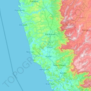
Name: Sindhudurg topographic map, elevation, terrain.
Location: Sindhudurg, Maharashtra, India (15.60636 73.31116 16.66493 74.20872)
Average elevation: 202 m
Minimum elevation: -2 m
Maximum elevation: 1,045 m
Thank you for supporting this site ❤️
Make a donation
Make a donation
Other topographic maps
Click on a map to view its topography, its elevation and its terrain.
Ichalkaranji
India > Maharashtra > Hatkanangle
Ichalkaranji is located at 16°42′N 74°28′E / 16.7°N 74.47°E / 16.7; 74.47. It has an average elevation of 538 metres (1768 ft).
Average elevation: 562 m
Thank you for supporting this site ❤️
Make a donation
Make a donation