
Make a donation
La Unión topographic map
Click on the map to display elevation.
Make a donation
La Unión
La Unión is situated in the Region of Murcia in the southeast of Spain. It has an area of 24.6 km², and had a population of 19,907 on 1 January 2018. It has an elevation of 86 m. Its average annual temperature is 17 °C. It has balmy winters. The sun shines 320 days per year. La Unión is situated in one of the sunniest areas in Europe; this kind of climate makes possible the many leisure activities, popular fiestas, sports, and cultural activities that are held in the town. The town is linked by a regular train to Cartagena which allows views of the past industrial heritage of the area (lead, alum and silver mining) and the more modern occupations of agriculture and tourism. La Unión lies within the built-up area of Cartagena and is surrounded on all landward sides by the City of Cartagena.
Make a donation
About this map
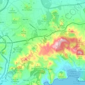
Name: La Unión topographic map, elevation, terrain.
Average elevation: 110 m
Minimum elevation: -4 m
Maximum elevation: 381 m
Make a donation
Other topographic maps
Click on a map to view its topography, its elevation and its terrain.
Cabezo de la Plata
Spain > Region of Murcia > Campo de Cartagena y Mar Menor > Cartagena
Average elevation: 85 m
Monte Sacro
Spain > Region of Murcia > Campo de Cartagena y Mar Menor > Cartagena
Average elevation: 12 m