
Thank you for supporting this site ❤️
Make a donation
Make a donation
Moguer topographic map
Click on the map to display elevation.
Thank you for supporting this site ❤️
Make a donation
Make a donation
Moguer
The urban centre of Moguer is located at 37° 16′ N, 6° 50′ W, at an altitude of 51 metres (167 ft), 19 kilometres (12 mi) from the provincial capital Huelva, and 80 kilometres (50 mi) from the Andalusian capital Seville. It is very close to Palos de la Frontera, and 20 kilometres (12 mi) from the beaches of Mazagón; all of these are within the mancomunidad Moguer-Palos de la Frontera and the larger Comarca Metropolitana de Huelva. Its surface area is 204 square kilometres (79 sq mi).
Thank you for supporting this site ❤️
Make a donation
Make a donation
About this map
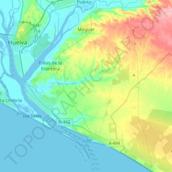
Name: Moguer topographic map, elevation, terrain.
Average elevation: 32 m
Minimum elevation: -2 m
Maximum elevation: 129 m
Thank you for supporting this site ❤️
Make a donation
Make a donation
Other topographic maps
Click on a map to view its topography, its elevation and its terrain.