
Thank you for supporting this site ❤️
Make a donation
Make a donation
Santeramo in Colle topographic map
Click on the map to display elevation.
Thank you for supporting this site ❤️
Make a donation
Make a donation
Santeramo in Colle
By altitude, Santeramo in Colle is the highest municipality in the metropolitan city of Bari.
Thank you for supporting this site ❤️
Make a donation
Make a donation
About this map
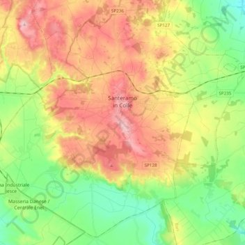
Name: Santeramo in Colle topographic map, elevation, terrain.
Location: Santeramo in Colle, Bari, Apulia, 70029, Italy (40.71177 16.65600 40.84878 16.84975)
Average elevation: 418 m
Minimum elevation: 334 m
Maximum elevation: 519 m
Thank you for supporting this site ❤️
Make a donation
Make a donation
Other topographic maps
Click on a map to view its topography, its elevation and its terrain.