
Thank you for supporting this site ❤️
Make a donation
Make a donation
Weilheim in Oberbayern topographic map
Click on the map to display elevation.
Thank you for supporting this site ❤️
Make a donation
Make a donation
About this map
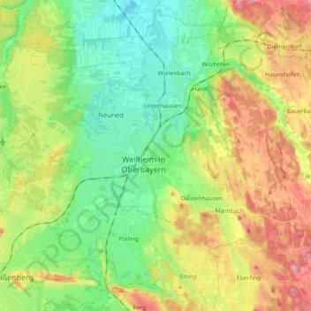
Name: Weilheim in Oberbayern topographic map, elevation, terrain.
Average elevation: 595 m
Minimum elevation: 535 m
Maximum elevation: 745 m
Thank you for supporting this site ❤️
Make a donation
Make a donation
Other topographic maps
Click on a map to view its topography, its elevation and its terrain.
Thank you for supporting this site ❤️
Make a donation
Make a donation
Schwabsoien
Germany > Bavaria > Landkreis Weilheim-Schongau > Schwabsoien > Schwabsoien
Average elevation: 763 m