
Alcalá de Henares topographic map
Interactive map
Click on the map to display elevation.
About this map
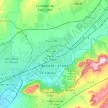
Name: Alcalá de Henares topographic map, elevation, terrain.
Location: Alcalá de Henares, Community of Madrid, Spain (40.44589 -3.44740 40.54510 -3.28378)
Average elevation: 642 m
Minimum elevation: 564 m
Maximum elevation: 870 m
Standing at an average altitude of 654 m, and occupying some 88 km2; the city was for a long time contained in between the Henares to the South and the Madrid-Barcelona railway to the North. However, the increasing population brought on the sprawl of the urbanised area to the area located in between the railway and the A-2 motorway and beyond.
Other topographic maps
Click on a map to view its topography, its elevation and its terrain.
Jardines del Descubrimiento
Spain > Community of Madrid > Madrid
Jardines del Descubrimiento, Recoletos, Salamanca, Madrid, Community of Madrid, Spain
Average elevation: 679 m
Castillejos
Spain > Community of Madrid > Área metropolitana de Madrid y Corredor del Henares > Madrid
Castillejos, Tetuán, Madrid, Área metropolitana de Madrid y Corredor del Henares, Community of Madrid, 28020, Spain
Average elevation: 716 m
Numancia
Spain > Community of Madrid > Madrid
Numancia, Puente de Vallecas, Madrid, Área metropolitana de Madrid y Corredor del Henares, Community of Madrid, 28001, Spain
Average elevation: 646 m
Villaverde
Spain > Community of Madrid > Madrid
Villaverde, Madrid, Community of Madrid, Spain
Average elevation: 597 m
San Diego
Spain > Community of Madrid > Madrid
San Diego, Puente de Vallecas, Madrid, Área metropolitana de Madrid y Corredor del Henares, Community of Madrid, 28001, Spain
Average elevation: 622 m
Tetuán
Spain > Community of Madrid > Madrid
Tetuán, Madrid, Área metropolitana de Madrid y Corredor del Henares, Community of Madrid, 28001, Spain
Average elevation: 711 m
Ríos Rosas
Spain > Community of Madrid > Madrid
Ríos Rosas, Chamberí, Madrid, Área metropolitana de Madrid y Corredor del Henares, Community of Madrid, 28001, Spain
Average elevation: 698 m
Manzanares
Manzanares, Área metropolitana de Madrid y Corredor del Henares, Community of Madrid, 28410, Spain
Average elevation: 765 m
El Atazar
Spain > Community of Madrid > El Atazar
El Atazar, Sierra Norte, Community of Madrid, Spain
Average elevation: 1,010 m
Hortaleza
Spain > Community of Madrid > Madrid
Hortaleza, Madrid, Área metropolitana de Madrid y Corredor del Henares, Community of Madrid, 28001, Spain
Average elevation: 687 m