
Montezuma County topographic map
Interactive map
Click on the map to display elevation.
About this map
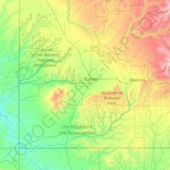
Name: Montezuma County topographic map, elevation, terrain.
Location: Montezuma County, Colorado, United States of America (36.99897 -109.04593 37.63775 -107.96859)
Average elevation: 2,025 m
Minimum elevation: 1,370 m
Maximum elevation: 3,978 m
A large county, roughly 1/3 of its area is tribal land, 1/3 is federal land (administered by the National Park Service, the United States Forest Service and the Bureau of Land Management), and 1/3 private or state/county land. It is also varied topographically, ranging in elevation from about 6,000 feet (1,800 m) to more than 13,200 feet (4,000 m), and from high Colorado Plateau desert to alpine tundra. The county has the second largest reservoir in Colorado, McPhee Reservoir, many other large reservoirs, and hundreds of private lakes and ponds. Much of the county is irrigated cropland, and it produces fruit, large numbers of cattle and sheep, and beans. It is served by U.S. Highways 160 and 491 (formerly US 666), and by Cortez Municipal Airport. It has no rail service, although both Mancos and Dolores were established as railroad towns in the 1890s.
Other topographic maps
Click on a map to view its topography, its elevation and its terrain.
Lakewood
United States of America > Colorado > Lakewood
Lakewood, Jefferson County, Colorado, United States of America
Average elevation: 1,690 m
Saguache County
United States of America > Colorado
Saguache County, Colorado, United States of America
Average elevation: 2,819 m
Kutch
United States of America > Colorado > Kutch
Kutch, Elbert County, Colorado, United States of America
Average elevation: 1,727 m
Mineral County
United States of America > Colorado
Mineral County, Colorado, United States of America
Average elevation: 3,202 m
Boulder
United States of America > Colorado > Boulder
Boulder, Boulder County, Colorado, United States of America
Average elevation: 1,786 m
Mount Wilson
United States of America > Colorado
Mount Wilson, Dolores County, Colorado, United States of America
Average elevation: 3,891 m
Arapahoe County
United States of America > Colorado
Arapahoe County, Colorado, United States of America
Average elevation: 1,693 m
Montrose County
United States of America > Colorado
Montrose County, Colorado, United States of America
Average elevation: 2,307 m
Pueblo County
United States of America > Colorado
Pueblo County, Colorado, United States of America
Average elevation: 1,629 m
La Plata County
United States of America > Colorado
La Plata County, Colorado, United States of America
Average elevation: 2,526 m
Grand County
United States of America > Colorado
Grand County, Colorado, United States of America
Average elevation: 2,899 m
Gunnison County
United States of America > Colorado
Gunnison County, Colorado, United States of America
Average elevation: 2,892 m
Larimer County
United States of America > Colorado
Larimer County, Colorado, United States of America
Average elevation: 2,363 m
Boulder County
United States of America > Colorado
Boulder County, Colorado, United States of America
Average elevation: 2,309 m