
Thank you for supporting this site ❤️
Make a donation
Make a donation
Vallåsen topographic map
Click on the map to display elevation.
Thank you for supporting this site ❤️
Make a donation
Make a donation
About this map
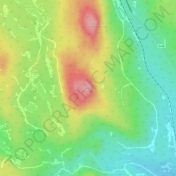
Name: Vallåsen topographic map, elevation, terrain.
Location: Vallåsen, Ljusdals kommun, Gävleborg County, Sweden (61.66078 14.75658 61.66088 14.75668)
Average elevation: 496 m
Minimum elevation: 429 m
Maximum elevation: 596 m
Thank you for supporting this site ❤️
Make a donation
Make a donation
Other topographic maps
Click on a map to view its topography, its elevation and its terrain.
Thank you for supporting this site ❤️
Make a donation
Make a donation
Thank you for supporting this site ❤️
Make a donation
Make a donation
Thank you for supporting this site ❤️
Make a donation
Make a donation