
Make a donation
Hillsborough topographic map
Click on the map to display elevation.
Make a donation
Hillsborough
According to the United States Census Bureau, the town has a total area of 6.2 square miles (16 km2), all of it land. The area's considerably winding, hilly topography, and impossibility of a grid layout make Hillsborough notoriously challenging to navigate. Many lots include fairly steep slopes, particularly the western side of the town, with the landscape generally flattening to the east as it descends from the 280 freeway to El Camino Real and the towns of Burlingame and San Mateo.
Make a donation
About this map
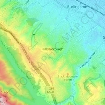
Name: Hillsborough topographic map, elevation, terrain.
Location: Hillsborough, San Mateo County, California, United States (37.53005 -122.39343 37.58085 -122.32838)
Average elevation: 100 m
Minimum elevation: 3 m
Maximum elevation: 331 m
Make a donation
Other topographic maps
Click on a map to view its topography, its elevation and its terrain.
San Carlos
United States > California > San Mateo County > San Carlos > San Carlos
Average elevation: 47 m