
Thank you for supporting this site ❤️
Make a donation
Make a donation
Belœil topographic map
Click on the map to display elevation.
Thank you for supporting this site ❤️
Make a donation
Make a donation
Belœil
Both an agricultural and touristic municipality, Belœil spans an altitude ranging from 25 m in the west, near the E42 highway, to 95 m in the southeast, within the Stambruges forest.
Thank you for supporting this site ❤️
Make a donation
Make a donation
About this map
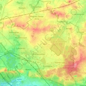
Name: Belœil topographic map, elevation, terrain.
Location: Belœil, Ath, Hainaut, Wallonia, Belgium (50.48092 3.60852 50.58172 3.76060)
Average elevation: 57 m
Minimum elevation: 17 m
Maximum elevation: 98 m
Thank you for supporting this site ❤️
Make a donation
Make a donation
Other topographic maps
Click on a map to view its topography, its elevation and its terrain.