
Minneapolis topographic map
Click on the map to display elevation.
Minneapolis
A 1959 report by the US Soil Conservation Service listed Minneapolis's elevation above mean sea level as 830 feet (250 meters). The city's lowest elevation of 687 feet (209 m) above sea level is near the confluence of Minnehaha Creek with the Mississippi River. Sources disagree on the exact location and elevation of the city's highest point, which is cited as being between 967 and 985 feet (295 and 300 m) above sea level.
About this map
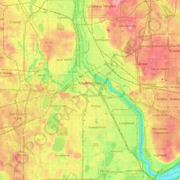
Name: Minneapolis topographic map, elevation, terrain.
Location: Minneapolis, Hennepin County, Minnesota, United States (44.89015 -93.32913 45.05125 -93.19386)
Average elevation: 270 m
Minimum elevation: 211 m
Maximum elevation: 318 m
Other topographic maps
Click on a map to view its topography, its elevation and its terrain.
Elm Creek Park (Maple Grove Arboretum)
United States > Minnesota > Hennepin County > Maple Grove
Average elevation: 278 m
Pond-Dakota Mission Park
United States > Minnesota > Hennepin County > Bloomington
Average elevation: 235 m
Mississippi River
United States > Minnesota > Hennepin County > Minneapolis
The uppermost lock and dam on the Upper Mississippi River is the Upper St. Anthony Falls Lock and Dam in Minneapolis. Above the dam, the river's elevation is 799 feet (244 m). Below the dam, the river's elevation is 750 feet (230 m). This 49-foot (15 m) drop is the largest of all the Mississippi River locks…
Average elevation: 256 m
Eden Prairie
United States > Minnesota > Hennepin County > Eden Prairie > Eden Prairie
Average elevation: 267 m
Minnehaha Falls
United States > Minnesota > Hennepin County > Minneapolis
Fortunately for the generations to come, in 1883 the state legislature created the Minneapolis Board of Park Commissioners. The board began by acquiring park land near today's downtown Minneapolis. Their choice to hire noted landscape architect Horace Cleveland was fortunate. Cleveland was hired by the Board…
Average elevation: 249 m