
Make a donation
Tuva Republic topographic map
Click on the map to display elevation.
Make a donation
About this map
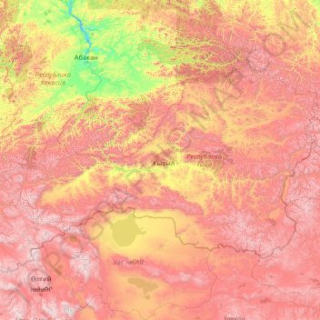
Name: Tuva Republic topographic map, elevation, terrain.
Location: Tuva Republic, Siberian Federal District, Russia (49.74293 88.79200 53.72893 99.27370)
Average elevation: 1,411 m
Minimum elevation: 224 m
Maximum elevation: 3,924 m
Make a donation
Other topographic maps
Click on a map to view its topography, its elevation and its terrain.
Make a donation
Make a donation
Make a donation
Make a donation
Make a donation
Astrakhan
Russia > Astrakhan Oblast > Astrakhan > Astrakhan
Astrakhan (Russian: Астрахань, tr. Astrakhan', IPA: ; Tatar: Cyrillic Әстерхан, Latin Ästerxan), is the largest city and administrative centre of Astrakhan Oblast in Southern Russia. The city lies on two banks of the Volga, in the upper part of the Volga Delta, on eleven islands of the…
Average elevation: -21 m
Tynda
Russia > Amur Oblast > городской округ Тында
The town is located at an elevation of 500 meters (1,600 ft) above sea level, near where the Getkan joins the Tynda River, after which the town was named. The Tynda then flows into the Gilyuy, a tributary of the Zeya, a few kilometers east of the town.
Average elevation: 566 m
Make a donation
Yekaterinburg
Russia > Sverdlovsk Oblast > Yekaterinburg Municipality > Yekaterinburg
Average elevation: 274 m
Make a donation
Make a donation
Ob
Russia > Yamalo-Nenets Autonomous Okrug > городской округ Лабытнанги > Labytnangi
Average elevation: 6 m
Make a donation