
Make a donation
Sellersville topographic map
Click on the map to display elevation.
Make a donation
About this map
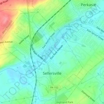
Name: Sellersville topographic map, elevation, terrain.
Average elevation: 112 m
Minimum elevation: 88 m
Maximum elevation: 167 m
Make a donation
Other topographic maps
Click on a map to view its topography, its elevation and its terrain.
Wood
United States > Pennsylvania > Bucks County > Bristol Township > Levittown
Average elevation: 15 m
Rosewood Park
United States > Pennsylvania > Bucks County > Warminster Township
Average elevation: 88 m
Make a donation
Cornwells Heights
United States > Pennsylvania > Bucks County > Bensalem Township
Average elevation: 16 m
Feasterville
United States > Pennsylvania > Bucks County > Lower Southampton Township
Average elevation: 66 m
Make a donation
Warminster Heights
United States > Pennsylvania > Bucks County > Warminster Township
Average elevation: 86 m
Gardenville
United States > Pennsylvania > Bucks County > Plumstead Township > Gardenville
Average elevation: 134 m