
Thank you for supporting this site ❤️
Make a donation
Make a donation
Rochehaut topographic map
Click on the map to display elevation.
Thank you for supporting this site ❤️
Make a donation
Make a donation
About this map
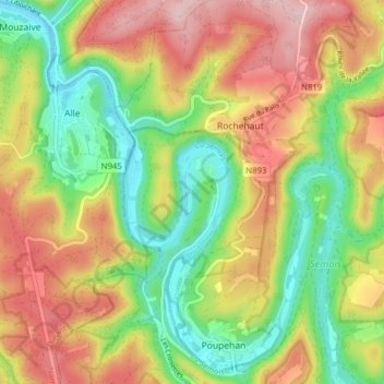
Name: Rochehaut topographic map, elevation, terrain.
Location: Rochehaut, Bouillon, Neufchâteau, Luxembourg, Wallonia, Belgium (49.80637 4.97086 49.85692 5.02732)
Average elevation: 296 m
Minimum elevation: 182 m
Maximum elevation: 431 m
Thank you for supporting this site ❤️
Make a donation
Make a donation
Other topographic maps
Click on a map to view its topography, its elevation and its terrain.