
Thank you for supporting this site ❤️
Make a donation
Make a donation
Borgo San Lorenzo topographic map
Click on the map to display elevation.
Thank you for supporting this site ❤️
Make a donation
Make a donation
About this map
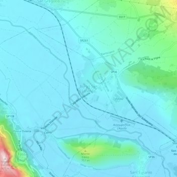
Name: Borgo San Lorenzo topographic map, elevation, terrain.
Location: Borgo San Lorenzo, Fossa, L'Aquila, Abruzzo, 67040, Italy (42.28771 13.48831 42.32771 13.52831)
Average elevation: 607 m
Minimum elevation: 562 m
Maximum elevation: 931 m
Thank you for supporting this site ❤️
Make a donation
Make a donation
Other topographic maps
Click on a map to view its topography, its elevation and its terrain.
Thank you for supporting this site ❤️
Make a donation
Make a donation
National Park of Abruzzo, Lazio and Molise
The predominant tree of the park is the beech which covers 60% of the area, generally grows at 900–1800 m altitude and provides a stunning display of color throughout the whole year. Notable also the presence of some old-growth beech forests in the northern part of the park. Other trees are the black pine,…
Average elevation: 1,135 m
Thank you for supporting this site ❤️
Make a donation
Make a donation
Thank you for supporting this site ❤️
Make a donation
Make a donation
Thank you for supporting this site ❤️
Make a donation
Make a donation
Thank you for supporting this site ❤️
Make a donation
Make a donation
Thank you for supporting this site ❤️
Make a donation
Make a donation
Thank you for supporting this site ❤️
Make a donation
Make a donation