
Thank you for supporting this site ❤️
Make a donation
Make a donation
Palora topographic map
Click on the map to display elevation.
Thank you for supporting this site ❤️
Make a donation
Make a donation
About this map
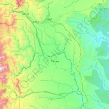
Name: Palora topographic map, elevation, terrain.
Location: Palora, Morona Santiago, Ecuador (-1.88023 -78.37730 -1.44832 -77.83130)
Average elevation: 1,041 m
Minimum elevation: 419 m
Maximum elevation: 3,328 m
Thank you for supporting this site ❤️
Make a donation
Make a donation
Other topographic maps
Click on a map to view its topography, its elevation and its terrain.
Sangay
Ecuador > Morona Santiago > Pablo Sexto > Pablo VI
Sangay is one of two active volcanoes in the Sangay National Park, the other being Tungurahua to the north. As such it has been listed as a UNESCO World Heritage Site since 1983. The area's isolation has allowed it to maintain a pristine ecology relatively untouched by human interaction, and the park hosts a…
Average elevation: 4,610 m