
Thank you for supporting this site ❤️
Make a donation
Make a donation
Reggio nell'Emilia topographic map
Click on the map to display elevation.
Thank you for supporting this site ❤️
Make a donation
Make a donation
About this map
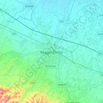
Name: Reggio nell'Emilia topographic map, elevation, terrain.
Location: Reggio nell'Emilia, Emilia-Romagna, Italy (44.62446 10.49102 44.77445 10.77334)
Average elevation: 68 m
Minimum elevation: 23 m
Maximum elevation: 408 m
Thank you for supporting this site ❤️
Make a donation
Make a donation
Other topographic maps
Click on a map to view its topography, its elevation and its terrain.
Terminaccio
Italy > Emilia-Romagna > Reggio nell'Emilia > Castelnovo ne' Monti > Garfagnolo
Average elevation: 706 m
Thank you for supporting this site ❤️
Make a donation
Make a donation
Thank you for supporting this site ❤️
Make a donation
Make a donation