
Scarborough topographic map
Interactive map
Click on the map to display elevation.
About this map
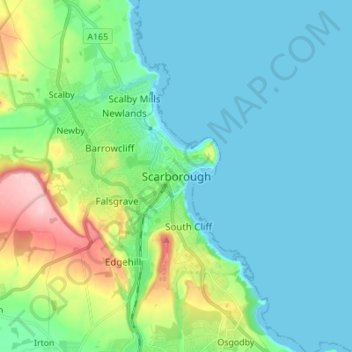
Name: Scarborough topographic map, elevation, terrain.
Average elevation: 39 m
Minimum elevation: -1 m
Maximum elevation: 184 m
The climate is temperate with mild summers and cool, windy, winters. The hottest months of the year are July and August, with temperatures reaching an average high of 17 °C and falling to 11 °C at night. The average daytime temperatures in January are 4 °C, falling to 1 °C at night. The station's elevation of 110 m (360 ft) is far above sea level compared to the immediate coastline, where the climate is likely slightly milder year round.
Other topographic maps
Click on a map to view its topography, its elevation and its terrain.
Whitby
United Kingdom > England > North Yorkshire
Whitby, North Yorkshire, England, United Kingdom
Average elevation: 37 m
Harrogate
United Kingdom > England > North Yorkshire
Harrogate, North Yorkshire, England, HG1 1RD, United Kingdom
Average elevation: 106 m