
Make a donation
Guatemala City topographic map
Click on the map to display elevation.
Make a donation
Guatemala City
Despite its location in the tropics, Guatemala City's has a tropical savanna climate (Köppen Aw) bordering humid subtropical climate (Cwa), relatively high altitude moderates average temperatures. Guatemala City is generally very warm, almost springlike, throughout the course of the year. It occasionally gets hot during the dry season, but not as hot and humid as in Central American cities at sea level. The hottest month is April. The rainy season extends from May to October, coinciding with the tropical storm and hurricane season in the western Atlantic Ocean and Caribbean Sea, while the dry season extends from November to April. The city can at times be windy, which also leads to lower ambient temperatures.
Make a donation
About this map
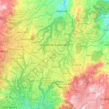
Name: Guatemala City topographic map, elevation, terrain.
Location: Guatemala City, Zona 11, Guatemala Department, Guatemala (14.53641 -90.58709 14.71379 -90.38541)
Average elevation: 1,538 m
Minimum elevation: 1,164 m
Maximum elevation: 2,038 m
Make a donation
Other topographic maps
Click on a map to view its topography, its elevation and its terrain.
Santa Catarina Pinula
Guatemala > Guatemala Department > Santa Catarina Pinula
Average elevation: 1,581 m
Colonia Villa de San Juan
Guatemala > Guatemala Department > Guatemala City
Average elevation: 1,535 m
Make a donation
Make a donation