
Thank you for supporting this site ❤️
Make a donation
Make a donation
Cabuderra/Capoterra topographic map
Click on the map to display elevation.
Thank you for supporting this site ❤️
Make a donation
Make a donation
About this map
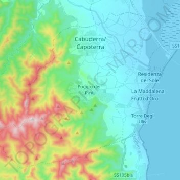
Name: Cabuderra/Capoterra topographic map, elevation, terrain.
Location: Cabuderra/Capoterra, Casteddu/Cagliari, Sardinia, 09012, Italy (39.10184 8.89348 39.19320 9.02925)
Average elevation: 162 m
Minimum elevation: -3 m
Maximum elevation: 726 m
Thank you for supporting this site ❤️
Make a donation
Make a donation
Other topographic maps
Click on a map to view its topography, its elevation and its terrain.