
Thank you for supporting this site ❤️
Make a donation
Make a donation
Artic topographic map
Click on the map to display elevation.
Thank you for supporting this site ❤️
Make a donation
Make a donation
About this map
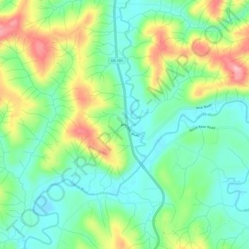
Name: Artic topographic map, elevation, terrain.
Location: Artic, Grays Harbor County, Washington, United States (46.87032 -123.73528 46.91032 -123.69528)
Average elevation: 75 m
Minimum elevation: 22 m
Maximum elevation: 175 m
Thank you for supporting this site ❤️
Make a donation
Make a donation
Other topographic maps
Click on a map to view its topography, its elevation and its terrain.
Aberdeen
United States > Washington > Grays Harbor County
Aberdeen is at the eastern end of Grays Harbor, near the mouth of the Chehalis River and southwest of the Olympic Mountains. Grays Harbor is notable as the northernmost ria on North America's Pacific Coast because it has remained free of glaciers throughout the Quaternary due to unfavorable topography and warm…
Average elevation: 48 m