
Thank you for supporting this site ❤️
Make a donation
Make a donation
Taichung topographic map
Click on the map to display elevation.
Thank you for supporting this site ❤️
Make a donation
Make a donation
About this map
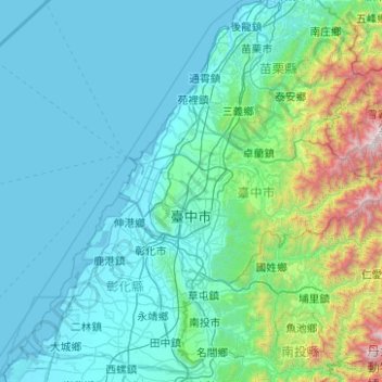
Name: Taichung topographic map, elevation, terrain.
Location: Taichung, Taiwan (23.99856 120.45656 24.44151 121.45096)
Average elevation: 379 m
Minimum elevation: -2 m
Maximum elevation: 3,471 m
Thank you for supporting this site ❤️
Make a donation
Make a donation
Other topographic maps
Click on a map to view its topography, its elevation and its terrain.