
Thank you for supporting this site ❤️
Make a donation
Make a donation
Plagne Villages topographic map
Click on the map to display elevation.
Thank you for supporting this site ❤️
Make a donation
Make a donation
About this map
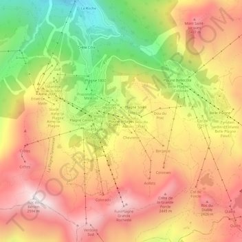
Name: Plagne Villages topographic map, elevation, terrain.
Average elevation: 2,104 m
Minimum elevation: 1,518 m
Maximum elevation: 2,561 m
Thank you for supporting this site ❤️
Make a donation
Make a donation
Other topographic maps
Click on a map to view its topography, its elevation and its terrain.
73210
France > Auvergne-Rhône-Alpes > Savoy > La Plagne-Tarentaise > Sangot
Average elevation: 1,766 m