
Coe Glacier topographic map
Interactive map
Click on the map to display elevation.
About this map
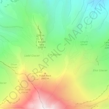
Name: Coe Glacier topographic map, elevation, terrain.
Location: Coe Glacier, Barrett Spur, Hood River County, Oregon, USA (45.37431 -121.70031 45.40296 -121.69016)
Average elevation: 2,328 m
Minimum elevation: 1,644 m
Maximum elevation: 3,345 m
Other topographic maps
Click on a map to view its topography, its elevation and its terrain.
Crater Lake National Park
USA > Oregon > Rim Village
Crater Lake National Park, Summit Trail, Rim Village, Klamath County, Oregon, 97604, USA
Average elevation: 1,726 m
Mount Tabor
Mount Tabor, Portland, Multnomah County, Oregon, 97215, USA
Average elevation: 86 m
Hayden Glacier
Hayden Glacier, climber's trail, Deschutes County, Oregon, USA
Average elevation: 2,542 m
Renfrew Glacier
Renfrew Glacier, climber's trail, Deschutes County, Oregon, USA
Average elevation: 2,538 m
Diller Glacier
Diller Glacier, climber's trail, Deschutes County, Oregon, USA
Average elevation: 2,416 m
Linn Glacier
Linn Glacier, Pacific Crest Trail, Deschutes County, Oregon, USA
Average elevation: 2,359 m
Prouty Glacier
Prouty Glacier, South Sister Climber Trail #36, Deschutes County, Oregon, USA
Average elevation: 2,589 m
Reid Glacier
Reid Glacier, Yocum Ridge Trail #771, Clackamas County, Oregon, USA
Average elevation: 2,410 m
Glisan Glacier
Glisan Glacier, McNeil Point Trail #600M, Hood River County, Oregon, USA
Average elevation: 2,086 m
Sandy Glacier
Sandy Glacier, Yocum Ridge Trail #771, Clackamas County, Oregon, USA
Average elevation: 2,365 m
Skinner Glacier
Skinner Glacier, South Sister Climber Trail #36, Deschutes County, Oregon, USA
Average elevation: 2,480 m
Bend Glacier
Bend Glacier, Broken Top NW Ridge route, Deschutes County, Oregon, USA
Average elevation: 2,350 m
Milk Creek Glacier
Milk Creek Glacier, Pacific Crest Trail, Jefferson County, Oregon, USA
Average elevation: 2,508 m
Wallowa Mountains
Wallowa Mountains, Wallowa County, Oregon, USA
Average elevation: 2,475 m
Three Fingered Jack
Three Fingered Jack, Linn County, Oregon, USA
Average elevation: 1,881 m
Ladd Glacier
Ladd Glacier, Barrett Spur, Hood River County, Oregon, USA
Average elevation: 2,305 m
Newton Clark Glacier
Newton Clark Glacier, Cooper Spur Trail #600B, Hood River County, Oregon, USA
Average elevation: 2,589 m
Carver Glacier
Carver Glacier, South Sister Climber Trail #36, Deschutes County, Oregon, USA
Average elevation: 2,385 m
Zigzag Glacier
Zigzag Glacier, Mountaineer Trail #798, Clackamas County, Oregon, USA
Average elevation: 2,620 m
Whitewater Glacier
Whitewater Glacier, Pacific Crest Trail, Jefferson County, Oregon, USA
Average elevation: 2,460 m
Benson Glacier
Benson Glacier, Eagle Cap Summit Trail, Union County, Oregon, USA
Average elevation: 2,489 m
Hosford-Abernethy
Hosford-Abernethy, Portland, Multnomah County, Oregon, USA
Average elevation: 26 m
Coalman Glacier
Coalman Glacier, Cooper Spur Trail #600B, Hood River County, Oregon, USA
Average elevation: 2,728 m
Waldo Glacier
Waldo Glacier, Pacific Crest Trail, Jefferson County, Oregon, USA
Average elevation: 2,352 m
Langille Glacier
Langille Glacier, Eliot west moraine, Hood River County, Oregon, USA
Average elevation: 2,165 m
Clark Glacier
Clark Glacier, South Sister Climber Trail #36, Deschutes County, Oregon, USA
Average elevation: 2,578 m
Lost Creek Glacier
Lost Creek Glacier, South Sister Climber Trail #36, Deschutes County, Oregon, USA
Average elevation: 2,430 m
Cove Orchard
USA > Oregon > Cove Orchard
Cove Orchard, Yamhill County, Oregon, 97148, USA
Average elevation: 126 m
Lathrop Glacier
Lathrop Glacier, Mt. Thielsen climber's trail, Douglas County, Oregon, USA
Average elevation: 2,235 m
Thayer Glacier
Thayer Glacier, climber's trail, Deschutes County, Oregon, USA
Average elevation: 2,423 m
Palmer Glacier
Palmer Glacier, Mountaineer Trail #798, Clackamas County, Oregon, USA
Average elevation: 2,424 m