
Sejny County topographic map
Interactive map
Click on the map to display elevation.
About this map
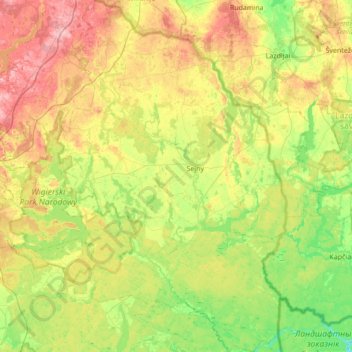
Name: Sejny County topographic map, elevation, terrain.
Location: Sejny County, Podlaskie Voivodeship, Poland (53.89421 23.07989 54.29700 23.52860)
Average elevation: 144 m
Minimum elevation: 85 m
Maximum elevation: 243 m
Other topographic maps
Click on a map to view its topography, its elevation and its terrain.
Augustów
Poland > Podlaskie Voivodeship > Augustów
Augustów, Augustów County, Podlaskie Voivodeship, 16-300, Poland
Average elevation: 129 m