
Thank you for supporting this site ❤️
Make a donation
Make a donation
San Antonio topographic map
Click on the map to display elevation.
Thank you for supporting this site ❤️
Make a donation
Make a donation
About this map
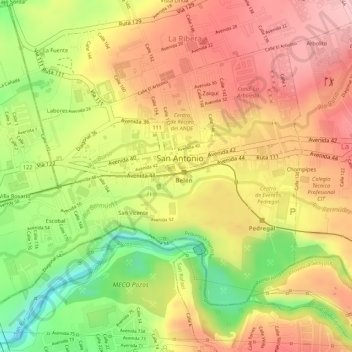
Name: San Antonio topographic map, elevation, terrain.
Average elevation: 914 m
Minimum elevation: 810 m
Maximum elevation: 982 m
Thank you for supporting this site ❤️
Make a donation
Make a donation
Other topographic maps
Click on a map to view its topography, its elevation and its terrain.
Thank you for supporting this site ❤️
Make a donation
Make a donation
Thank you for supporting this site ❤️
Make a donation
Make a donation
Thank you for supporting this site ❤️
Make a donation
Make a donation
Thank you for supporting this site ❤️
Make a donation
Make a donation
Thank you for supporting this site ❤️
Make a donation
Make a donation
Thank you for supporting this site ❤️
Make a donation
Make a donation
Thank you for supporting this site ❤️
Make a donation
Make a donation
Thank you for supporting this site ❤️
Make a donation
Make a donation
Thank you for supporting this site ❤️
Make a donation
Make a donation
Thank you for supporting this site ❤️
Make a donation
Make a donation
Cruce de Jordan
Costa Rica > Limón Province > Cantón Pococí > Rita > Cruce de Jordan
Average elevation: 114 m
Thank you for supporting this site ❤️
Make a donation
Make a donation
Thank you for supporting this site ❤️
Make a donation
Make a donation
Thank you for supporting this site ❤️
Make a donation
Make a donation
Cartago
Costa Rica > Cantón Cartago > Oriental
It has an elevation of 1,435 m (4,708 ft) above sea level, at the base of the Irazú Volcano.
Average elevation: 1,706 m
Thank you for supporting this site ❤️
Make a donation
Make a donation