
Make a donation
San Leandro topographic map
Click on the map to display elevation.
Make a donation
San Leandro
The San Leandro Hills run above the city to the northeast. In the lower elevations of the city, an upper regionally contained aquifer is located 50 to 100 feet (15 to 30 m) below the surface. At least one deeper aquifer exists approximately 250 feet (75 m) below the surface. Some salt water intrusion has taken place in the San Leandro Cone. Shallow groundwater generally flows to the west, from the foothills toward San Francisco Bay. Shallow groundwater is contaminated in many of the locales of the lower elevation of the city. Contamination by gasoline, volatile organic compounds and some heavy metals has been recorded in a number of these lower-elevation areas.
Make a donation
About this map
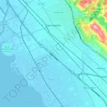
Name: San Leandro topographic map, elevation, terrain.
Average elevation: 21 m
Minimum elevation: -5 m
Maximum elevation: 238 m
Make a donation
Other topographic maps
Click on a map to view its topography, its elevation and its terrain.