
Make a donation
Salinas Grandes topographic map
Click on the map to display elevation.
Make a donation
Salinas Grandes
The Salinas Grandes ('Salina' is a spanish word for salt flat) is a large salt flat in central-northern Argentina, spanning the borders of four provinces (Córdoba, Catamarca, La Rioja and Santiago del Estero), at an average altitude of 180 metres (590 ft) above sea level, and having an area of about 4,700 km2.
Make a donation
About this map
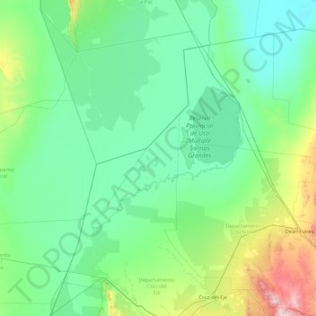
Name: Salinas Grandes topographic map, elevation, terrain.
Location: Salinas Grandes, Catamarca, Argentina (-30.80839 -65.68271 -29.36816 -64.65039)
Average elevation: 303 m
Minimum elevation: 110 m
Maximum elevation: 1,668 m
Make a donation
Other topographic maps
Click on a map to view its topography, its elevation and its terrain.
Monte Pissis
Argentina > Catamarca > Municipio de Fiambalá
A 1994 Argentine expedition claimed —using GPS technology available at the time— that the elevation of Monte Pissis was 6,882 m (22,579 ft), higher than Ojos del Salado. Ten years later, with the use of higher precision systems, several other surveys proved that those measurements were inaccurate: in 2005,…
Average elevation: 6,465 m
Make a donation