
South Island topographic map
Interactive map
Click on the map to display elevation.
About this map
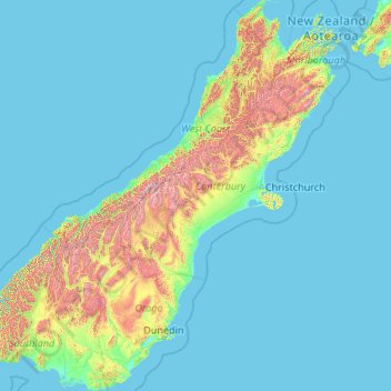
Name: South Island topographic map, elevation, terrain.
Location: South Island, Mackenzie District, Canterbury, New Zealand (-46.67550 166.42555 -40.49786 174.31586)
Average elevation: 201 m
Minimum elevation: -1 m
Maximum elevation: 2,987 m
Other topographic maps
Click on a map to view its topography, its elevation and its terrain.
Christchurch
New Zealand > Canterbury > Christchurch City
Christchurch, Christchurch City, Canterbury, New Zealand
Average elevation: 41 m
Spreydon-Cashmere Community
New Zealand > Canterbury > Christchurch City
Spreydon-Cashmere Community, Christchurch City, Canterbury, New Zealand
Average elevation: 102 m
Earthquakes
Earthquakes, Waitaki District, Canterbury, New Zealand
Average elevation: 237 m
Godley Glacier
Godley Glacier, Mackenzie District, Canterbury, New Zealand
Average elevation: 1,802 m
Te Hīwai / Murchison Glacier
Te Hīwai / Murchison Glacier, Mackenzie District, Canterbury, New Zealand
Average elevation: 1,875 m
Ball Glacier
Ball Glacier, Caroline hut to ball hut, Mackenzie District, Canterbury, New Zealand
Average elevation: 1,324 m
Mount Cook
Mount Cook, Mackenzie District, Canterbury, New Zealand
Average elevation: 2,920 m
Maud Glacier
Maud Glacier, Mackenzie District, Canterbury, New Zealand
Average elevation: 1,711 m
Mount Hutt
Mount Hutt, Ashburton District, Canterbury, New Zealand
Average elevation: 1,732 m
Southern Alps
Southern Alps, Mackenzie District, Canterbury, New Zealand
Average elevation: 2,832 m
Mount Dampier
Mount Dampier, Mackenzie District, Canterbury, New Zealand
Average elevation: 2,847 m
Mount Vancouver
Mount Vancouver, Mackenzie District, Canterbury, New Zealand
Average elevation: 2,804 m
Mueller Glacier
New Zealand > Canterbury > Mount Cook Village
Mueller Glacier, Mueller Hut Route, Mount Cook Village, Mackenzie District, Canterbury, 7946, New Zealand
Average elevation: 1,616 m
Godley Glacier
Godley Glacier, Mackenzie District, Canterbury, New Zealand
Average elevation: 1,579 m
Aida Glacier
Aida Glacier, Mackenzie District, Canterbury, New Zealand
Average elevation: 1,999 m
South Peak
South Peak, Ashburton District, Canterbury, New Zealand
Average elevation: 1,886 m