
Thank you for supporting this site ❤️
Make a donation
Make a donation
Neunburg vorm Wald topographic map
Click on the map to display elevation.
Thank you for supporting this site ❤️
Make a donation
Make a donation
About this map
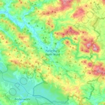
Name: Neunburg vorm Wald topographic map, elevation, terrain.
Average elevation: 464 m
Minimum elevation: 366 m
Maximum elevation: 696 m
Thank you for supporting this site ❤️
Make a donation
Make a donation
Other topographic maps
Click on a map to view its topography, its elevation and its terrain.
Bruck in der Oberpfalz
Germany > Bavaria > Landkreis Schwandorf > Bruck i.d.OPf.
Average elevation: 404 m