
Make a donation
Río Grande topographic map
Click on the map to display elevation.
Make a donation
Río Grande
Over 96% of the municipality's area lies in the drainage basin of the Aguanaval River, the main watercourse in the area which flows south to north through the municipality. This river was known as the Río Grande in the 16th and 17th centuries despite its modest size. The highest point in the municipality is the Cerro Tetilla Grande located at 23°41′N 102°51′W / 23.683°N 102.850°W / 23.683; -102.850 with an elevation of 2,370 metres (7,780 ft) above sea level.
Make a donation
About this map
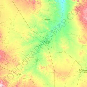
Name: Río Grande topographic map, elevation, terrain.
Location: Río Grande, Zacatecas, 98400, Mexico (23.55942 -103.39197 24.06550 -102.67373)
Average elevation: 2,059 m
Minimum elevation: 1,748 m
Maximum elevation: 2,663 m
Make a donation
Other topographic maps
Click on a map to view its topography, its elevation and its terrain.
Cinco Hermanos (José Luis Alba) [Rancho]
Mexico > Zacatecas > Fresnillo > José María Morelos
Average elevation: 2,041 m
La Laguna (La Laguna Valenciana)
Mexico > Zacatecas > General Francisco R. Murguía
Average elevation: 2,048 m
Make a donation
Make a donation
Sombrerete
Mexico > Zacatecas > Sombrerete
The region is between the Sierra Madre Occidental and the central highlands of Mexico. The municipality is in a valley is surrounded on all sides by small mountain ranges such as the Sierra de Sombrerete and the Sierra de Santa María with prominent elevations such as the Cerro Grande, Cerro Reyes, Cerro…
Average elevation: 2,401 m
Make a donation
Zacatecas City
Mexico > Zacatecas > Municipio de Zacatecas
The municipality is wedged between the Sierra Madre Occidental and the subrange called Sierras y Valles Zacatecanos. The area is very rugged terrain filled with narrow valleys, ravines and mountains. The principal elevations include Cerro El Grillo at 2,690 m (8,830 ft), Cerro Los Alamitos at 2,680 m (8,790…
Average elevation: 2,290 m
Make a donation