
Thank you for supporting this site ❤️
Make a donation
Make a donation
Pont-à-Celles topographic map
Click on the map to display elevation.
Thank you for supporting this site ❤️
Make a donation
Make a donation
About this map
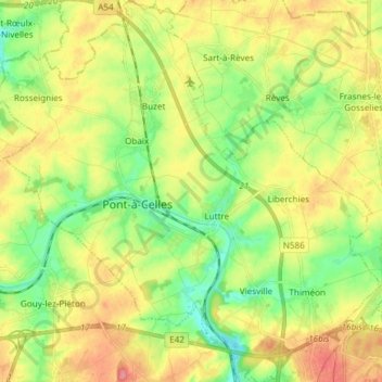
Name: Pont-à-Celles topographic map, elevation, terrain.
Location: Pont-à-Celles, Charleroi, Hainaut, Wallonie, Belgique (50.46793 4.30737 50.56288 4.45636)
Average elevation: 147 m
Minimum elevation: 112 m
Maximum elevation: 190 m
Thank you for supporting this site ❤️
Make a donation
Make a donation
Other topographic maps
Click on a map to view its topography, its elevation and its terrain.
Thank you for supporting this site ❤️
Make a donation
Make a donation
Thank you for supporting this site ❤️
Make a donation
Make a donation