
Thank you for supporting this site ❤️
Make a donation
Make a donation
San Germán topographic map
Click on the map to display elevation.
Thank you for supporting this site ❤️
Make a donation
Make a donation
About this map
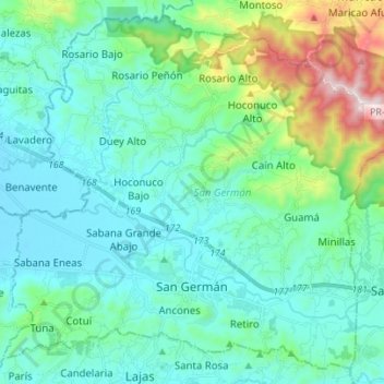
Name: San Germán topographic map, elevation, terrain.
Location: San Germán, Puerto Rico, United States (18.05254 -67.10909 18.17415 -66.97035)
Average elevation: 178 m
Minimum elevation: 15 m
Maximum elevation: 881 m
Thank you for supporting this site ❤️
Make a donation
Make a donation
Other topographic maps
Click on a map to view its topography, its elevation and its terrain.