
Thank you for supporting this site ❤️
Make a donation
Make a donation
Djasr Kasentina topographic map
Click on the map to display elevation.
Thank you for supporting this site ❤️
Make a donation
Make a donation
About this map
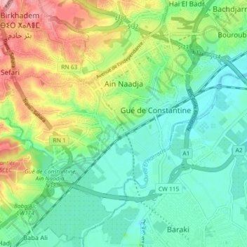
Name: Djasr Kasentina topographic map, elevation, terrain.
Location: Djasr Kasentina, Bir Mourad Rais District, Algiers, Algeria (36.67212 3.04255 36.71375 3.11485)
Average elevation: 56 m
Minimum elevation: 3 m
Maximum elevation: 155 m
Thank you for supporting this site ❤️
Make a donation
Make a donation
Other topographic maps
Click on a map to view its topography, its elevation and its terrain.
Gué de Constantine
Algeria > Algiers > Bir Mourad Rais District > Gué de Constantine
Average elevation: 48 m
Thank you for supporting this site ❤️
Make a donation
Make a donation