
Mahlsdorf topographic map
Interactive map
Click on the map to display elevation.
About this map
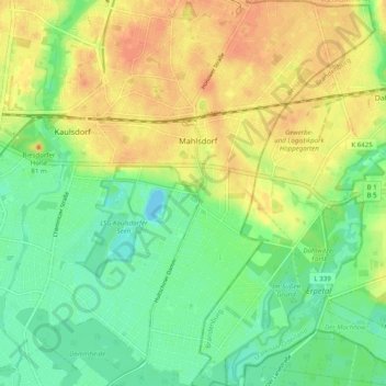
Name: Mahlsdorf topographic map, elevation, terrain.
Location: Mahlsdorf, Marzahn-Hellersdorf, Berlin, 12623, Germany (52.47048 13.58397 52.53059 13.65859)
Average elevation: 48 m
Minimum elevation: 30 m
Maximum elevation: 65 m
Other topographic maps
Click on a map to view its topography, its elevation and its terrain.
Universum Landes-Ausstellungs-Park
Universum Landes-Ausstellungs-Park, Moabit, Mitte, Berlin, Germany
Average elevation: 38 m