
Make a donation
Antioquia topographic map
Click on the map to display elevation.
Make a donation
Antioquia
Due to its geographical isolation (as it is located among mountains), Antioquia suffered supply problems. Its topography did not allow for much agriculture, so the city became dependent upon trade, especially of gold and gin for the colonization of new land. Much of this trade was due to reforms passed after a 1785 visit from Juan Antonio Mon y Velarde, an inspector of the Spanish Crown. The Antioquia became colonizers and traders.
Make a donation
About this map
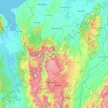
Name: Antioquia topographic map, elevation, terrain.
Location: Antioquia, RAP del Agua y la Montaña, Colombia (5.41863 -77.12709 8.88980 -73.87959)
Average elevation: 608 m
Minimum elevation: -4 m
Maximum elevation: 3,838 m
Make a donation
Other topographic maps
Click on a map to view its topography, its elevation and its terrain.