
Make a donation
Bucaramanga topographic map
Click on the map to display elevation.
Make a donation
Bucaramanga
Bucaramanga is located on a plateau in the Cordillera Oriental of the Colombian Andes, and many residents occupy unstable lands descending steeply from the meseta. Westbound of it, the Rio de Oro Canyon is located at an altitude of 600 metres (2,000 ft) above sea level. Eastbound, the Andean Range rises up in high peaks, reaching almost 3,700 metres (12,100 ft) AMSL in the place locally known as "Paramo de Berlin". The city is located at 7°08′N 73°08′W / 7.133°N 73.133°W / 7.133; -73.133. The official metropolitan area includes the municipalities of: Girón, Piedecuesta and Floridablanca, but Lebrija is home to Bucaramanga's airport and is commonly considered part of greater Bucaramanga. Despite recent urbanization, all four neighboring municipalities contain extensive rural areas.
Make a donation
About this map
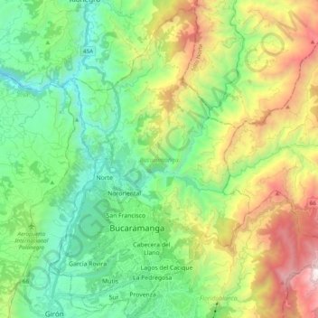
Name: Bucaramanga topographic map, elevation, terrain.
Average elevation: 1,268 m
Minimum elevation: 444 m
Maximum elevation: 2,993 m
Make a donation
Other topographic maps
Click on a map to view its topography, its elevation and its terrain.
Make a donation
Mirador del Cañon del Chicamocha
Colombia > Santander > Jordán > Villanueva
Average elevation: 1,139 m
Make a donation
Make a donation
Floridablanca
Colombia > Santander > Floridablanca > Floridablanca
Floridablanca is situated at an altitude of about 925 metres (3,035 ft) in the Eastern Ranges of the Colombian Andes, though locally the topography varies greatly. To the east of the city the higher mountains of the Andes rise above the city, thrusted upwards by the north–south-trending Bucaramanga-Santa…
Average elevation: 1,091 m
Make a donation