Geolocate
👉 Easily get elevation data in JSON, GeoTIFF and KML formats using Elevation API
Thank you for supporting this site ❤️
Make a donation

Nassogne topographic map

Click on the map to display elevation.

👉 Easily get elevation data in JSON, GeoTIFF and KML formats using Elevation API
Thank you for supporting this site ❤️
Make a donation

About this map

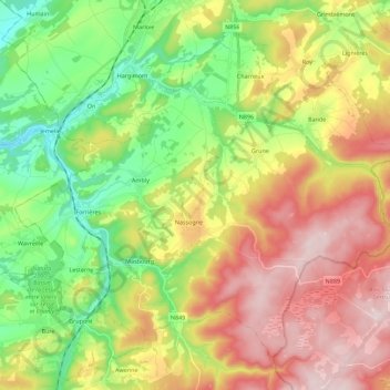
Name: Nassogne topographic map, elevation, terrain.

Location: Nassogne, Marche-en-Famenne, Luxembourg, Wallonia, Belgium (50.07851 5.24223 50.19984 5.46656)

Average elevation: 345 m

Minimum elevation: 174 m

Maximum elevation: 565 m

Other topographic maps

Click on a map to view its topography, its elevation and its terrain.

Freyneux

Belgium > Luxembourg > Marche-en-Famenne

Average elevation: 481 m

Tohogne

Belgium > Luxembourg > Marche-en-Famenne > Durbuy

Average elevation: 236 m

Bomal

Belgium > Luxembourg > Marche-en-Famenne > Durbuy

Average elevation: 201 m

Werpin

Belgium > Luxembourg > Marche-en-Famenne

Average elevation: 255 m

Hoursinne

Belgium > Luxembourg > Marche-en-Famenne > Mormont

Average elevation: 355 m

Ny

Belgium > Luxembourg > Marche-en-Famenne

Average elevation: 234 m

Ortheuville

Belgium > Luxembourg > Marche-en-Famenne

Average elevation: 395 m

Werpin

Belgium > Luxembourg > Marche-en-Famenne

Average elevation: 255 m

Waharday

Belgium > Luxembourg > Marche-en-Famenne

Average elevation: 310 m