
Make a donation
Emmaus topographic map
Click on the map to display elevation.
Make a donation
Emmaus
According to the U.S. Census Bureau, the borough has a total area of 2.9 square miles (7.5 km2), all land, though part of Little Lehigh Creek, a tributary of the Lehigh River, flows just outside the Emmaus border with Salisbury Township. Emmaus borders South Mountain, a large Appalachian mountain range. The town's elevation is 436 feet above sea level. Emmaus is located at approximately 40°32′13″N 75°29′45″W / 40.53694°N 75.49583°W / 40.53694; -75.49583. It has a hot-summer humid continental climate (Dfa) and is in hardiness zone 6b. Average monthly temperatures in the downtown vicinity range from 28.9 °F in January to 73.5 °F in July.
Make a donation
About this map
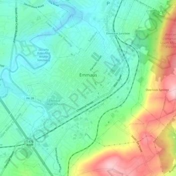
Name: Emmaus topographic map, elevation, terrain.
Location: Emmaus, Lehigh County, Pennsylvania, 18049, United States (40.51674 -75.52038 40.55645 -75.47900)
Average elevation: 154 m
Minimum elevation: 89 m
Maximum elevation: 296 m
Make a donation