
Mandulog River topographic map
Interactive map
Click on the map to display elevation.
About this map
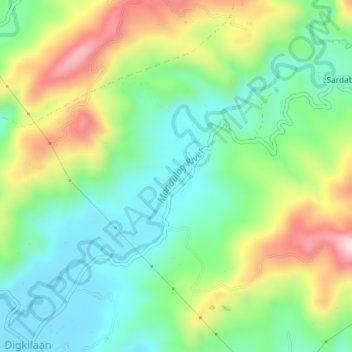
Name: Mandulog River topographic map, elevation, terrain.
Location: Mandulog River, Iligan, Northern Mindanao, Philippines (8.25224 124.31290 8.28055 124.34942)
Average elevation: 164 m
Minimum elevation: 26 m
Maximum elevation: 415 m
Other topographic maps
Click on a map to view its topography, its elevation and its terrain.
Agus
Philippines > Northern Mindanao > Iligan
Agus, Iligan, Northern Mindanao, 9201, Philippines
Average elevation: 208 m