
Barangay 89 topographic map
Interactive map
Click on the map to display elevation.
About this map
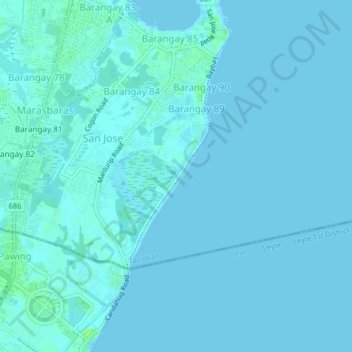
Name: Barangay 89 topographic map, elevation, terrain.
Location: Barangay 89, Tacloban, Eastern Visayas, 6500, Philippines (11.17899 125.00419 11.21899 125.04419)
Average elevation: 1 m
Minimum elevation: -2 m
Maximum elevation: 8 m
Other topographic maps
Click on a map to view its topography, its elevation and its terrain.
Kalipayan Culvert
Philippines > Tacloban > Barangay 62
Kalipayan Culvert, Bliss, San Fernando, Barangay 62, Tacloban, Eastern Visayas, 6500, Philippines
Average elevation: 4 m
Sitio Costa Brava
Philippines > Tacloban > Barangay 86
Sitio Costa Brava, Barangay 86, Tacloban, Eastern Visayas, 6500, Philippines
Average elevation: 1 m
Barangay 94 Tigbao
Barangay 94 Tigbao, Tacloban, Eastern Visayas, 6500, Philippines
Average elevation: 33 m
Barangay 100 San Roque
Barangay 100 San Roque, Tacloban, Eastern Visayas, Philippines
Average elevation: 80 m
Kapangian
Philippines > Tacloban > Kassel Homes
Kapangian, Kassel Homes, Tacloban, Eastern Visayas, 6500, Philippines
Average elevation: 33 m
Kassel Homes
Kassel Homes, Tacloban, Eastern Visayas, 6500, Philippines
Average elevation: 36 m
Barangay 76
Barangay 76, Tacloban, Eastern Visayas, 6500, Philippines
Average elevation: 5 m
Leyte Park
Leyte Park, Tacloban, Eastern Visayas, 6500, Philippines
Average elevation: 3 m
Barangay 66A
Barangay 66A, Tacloban, Eastern Visayas, 6500, Philippines
Average elevation: 14 m
Cabalawan
Philippines > Tacloban > Cabalawan
Cabalawan, Tacloban, Eastern Visayas, Philippines
Average elevation: 26 m
Abucay
Philippines > Tacloban > Abucay
Abucay, Tacloban, Eastern Visayas, 06500, Philippines
Average elevation: 46 m
Barangay 69
Barangay 69, Tacloban, Eastern Visayas, 6500, Philippines
Average elevation: 10 m