
Thank you for supporting this site ❤️
Make a donation
Make a donation
Dhule District topographic map
Click on the map to display elevation.
Thank you for supporting this site ❤️
Make a donation
Make a donation
About this map
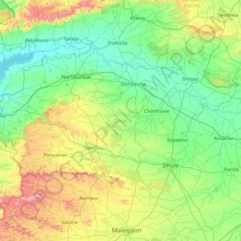
Name: Dhule District topographic map, elevation, terrain.
Location: Dhule District, Maharashtra, India (20.62736 73.85074 21.63446 75.20656)
Average elevation: 364 m
Minimum elevation: 95 m
Maximum elevation: 1,431 m
Thank you for supporting this site ❤️
Make a donation
Make a donation
Other topographic maps
Click on a map to view its topography, its elevation and its terrain.
Ichalkaranji
India > Maharashtra > Hatkanangle
Ichalkaranji is located at 16°42′N 74°28′E / 16.7°N 74.47°E / 16.7; 74.47. It has an average elevation of 538 metres (1768 ft).
Average elevation: 562 m
Thank you for supporting this site ❤️
Make a donation
Make a donation