
Make a donation
Auvergne topographic map
Click on the map to display elevation.
Make a donation
Auvergne
Auvergne is known for its mountain ranges and dormant volcanoes. Together the Monts Dore and the Chaîne des Puys include 80 volcanoes. The Puy de Dôme is the highest volcano in the region, with an altitude of 1,465 metres (4,806 ft). The Sancy Massif in the Monts Dore is the highest point in Auvergne (1,886 metres (6,188 ft)).
Make a donation
About this map
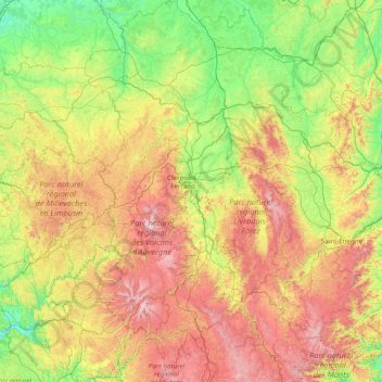
Name: Auvergne topographic map, elevation, terrain.
Location: Auvergne, Metropolitan France, France (44.61593 2.06290 46.80415 4.49046)
Average elevation: 587 m
Minimum elevation: 112 m
Maximum elevation: 1,828 m
Make a donation
Other topographic maps
Click on a map to view its topography, its elevation and its terrain.
La Villa Trévi
France > Auvergne-Rhône-Alpes > Upper Savoy > Épagny Metz-Tessy
Average elevation: 493 m
Cime de la Bonette
France > Provence-Alpes-Côte d'Azur > Maritime Alps > Saint-Dalmas-le-Selvage
Average elevation: 2,512 m
Make a donation
Make a donation
Aurafrède
France > Provence-Alpes-Côte d'Azur > Alpes-de-Haute-Provence > Gréoux-les-Bains
Average elevation: 389 m
Make a donation
Les Eschartès
France > Nouvelle-Aquitaine > Pyrénées-Atlantiques > Louvie-Soubiron
Average elevation: 942 m
Valence
France > Auvergne-Rhône-Alpes > Drôme
The area of the commune is 3,669 hectares (9,070 acres), representing 36.69 square kilometres (14.17 sq mi); the altitude varies between 106–191 metres (348–627 ft).
Average elevation: 287 m
Champ
France > Auvergne-Rhône-Alpes > Ardèche > Saint-Romain-de-Lerps > Roussiveyrent
Average elevation: 501 m
Make a donation
Make a donation
Fatu Huku
France > French Polynesia > Marquesas Islands > Hiva Oa
The island is essentially a huge rock, looming steep-sided out of the ocean and rising to a flattened plateau with a maximum elevation of 361 metres (1,184 ft). Fatu Huku is the youngest of the volcanic Marquesas Islands, estimated to be only 1.3 million years old which accounts, in part, for its ruggedness as…
Average elevation: 8 m
Make a donation
Agusan
France > New Aquitaine > Lot-et-Garonne > Laplume > Laplatrière de Bordeneuve
Average elevation: 159 m
Make a donation